Multi-cellular Thunderstorm & Gust Front
Archer Road Walmart, Gainesville, FL
July 06, 2008
One of the best ways to know when hazardous weather is heading
your way, during day or night, while you're awake or asleep, is with a NOAA
Weather Radio. Click on the above icon to learn more about it. It could
save your life.
Internet services providedfor freeby
Alachua County
SKYWARN
Watching the weather!
Multi-cellular Thunderstorm & Gust Front
Date/Time: July 06, 2008, 18:44 Hrs EDT Location: Southern Alachua County / Gainesville, FL Submitted By: Todd L. Sherman / KB4MHH
While in front of the Wal-Mart on Archer Road in Gainesville, FL, I took
time out to video a large thunderstorm to the southwest. I used a Raynoc
wide-angle lens and I'm definitely NOT happy with it. You can see why in
this video. You have the "binocular" shadow (aka "vignetting"), there is pretty
bad chromatic lens aberration. You've got the blue fringe, and the focus gets
worse and worse the farther from center that you do. I know. (sigh) But I
wanted the wide-angle shots. Later in the video I recorded an approaching gust
front from the storm.
(The Raynox wide angle teleconverter lens used here with my Canon HV-20 HD vidcam was of SUCH superiorly inferior quality I felt like I was using some cheap binoculars bought from a five and dime store or something. I've since purchased a Canon WD-H43 lens which is much better. Even gave it a bit of a review, here.)
SPC Storm Reports
While there were some storm reports from surrounding counties after this event, there were no reports of anything severe occurring within Alachua County.
Alachua County SKYWARN
Multi-cellular Thunderstorm & Gust Front
Gainesville, Alachua Co., Fla.
E-mail: admin@alachuaskywarn.org Created: April 13, 2012. Last updated: April 22, 2012.
![[Alachua Co. SKYWARN Logo]](../images/logos/acskyw3d.jpg)


![Some spotting/chasing-related educational links]](../images/buttons/study1.gif)


![[ANIM: NOAA/NWS-JAX Wx Radio Page]](../images/logos/nwr.gif)
![[ICON: Alachua County FreeNet]](../images/logos/freenet.jpg)
![[ANIM: SKYWARN Pog]](../anim/skywbutn.gif)
![[ANIM: Vid-Cam]](../anim/mscamera.gif)
![[ Multi-cell Thunderstorm & Gust Front ]](http://www.afn.org/~afn09444/weather/wxphotos/images/20080706-1844-MulticellStorm&GustFront01.jpg)
![[ Multi-cell Thunderstorm & Gust Front ]](http://www.afn.org/~afn09444/weather/wxphotos/images/20080706-1844-MulticellStorm&GustFront02.jpg)
![[ Multi-cell Thunderstorm & Gust Front ]](http://www.afn.org/~afn09444/weather/wxphotos/images/20080706-1844-MulticellStorm&GustFront03.jpg)
![[ Multi-cell Thunderstorm & Gust Front ]](http://www.afn.org/~afn09444/weather/wxphotos/images/20080706-1844-MulticellStorm&GustFront04.jpg)
![[ Multi-cell Thunderstorm & Gust Front ]](http://www.afn.org/~afn09444/weather/wxphotos/images/20080706-1844-MulticellStorm&GustFront05.jpg)
![[ Multi-cell Thunderstorm & Gust Front ]](http://www.afn.org/~afn09444/weather/wxphotos/images/20080706-1844-MulticellStorm&GustFront06.jpg)
![[ Multi-cell Thunderstorm & Gust Front ]](http://www.afn.org/~afn09444/weather/wxphotos/images/20080706-1844-MulticellStorm&GustFront07.jpg)
![[ Multi-cell Thunderstorm & Gust Front ]](http://www.afn.org/~afn09444/weather/wxphotos/images/20080706-1844-MulticellStorm&GustFront08.jpg)
![[ Multi-cell Thunderstorm & Gust Front ]](http://www.afn.org/~afn09444/weather/wxphotos/images/20080706-1844-MulticellStorm&GustFront09.jpg)
![[ Multi-cell Thunderstorm & Gust Front ]](http://www.afn.org/~afn09444/weather/wxphotos/images/20080706-1844-MulticellStorm&GustFront10.jpg)
![[ Multi-cell Thunderstorm & Gust Front ]](http://www.afn.org/~afn09444/weather/wxphotos/images/20080706-1844-MulticellStorm&GustFront11.jpg)
![[ Multi-cell Thunderstorm & Gust Front ]](http://www.afn.org/~afn09444/weather/wxphotos/images/20080706-1844-MulticellStorm&GustFront12.jpg)
![[ Multi-cell Thunderstorm & Gust Front ]](http://www.afn.org/~afn09444/weather/wxphotos/images/20080706-1844-MulticellStorm&GustFront13.jpg)
 [ Top of Page ]
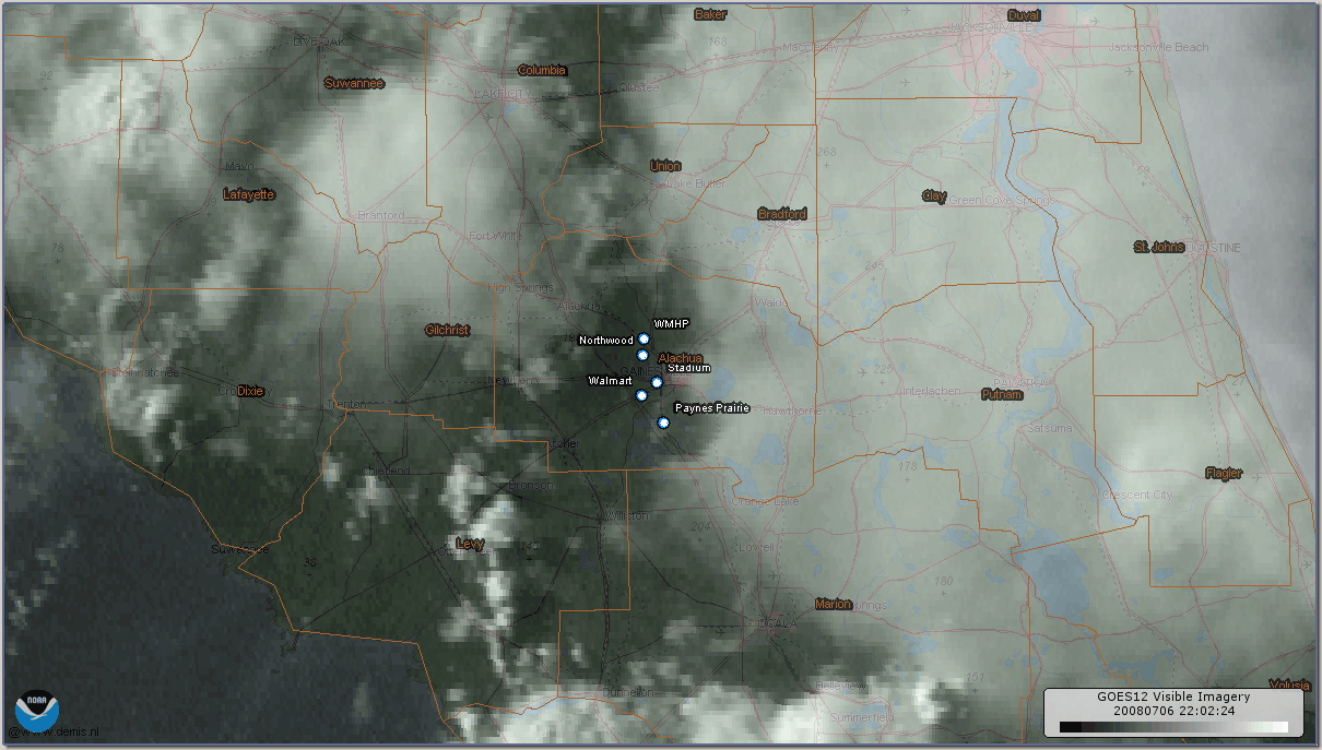