![]()
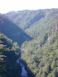
A surprisingly impressive gorge can be found on the Georgia/South Carolina border. Tallulah Gorge is one of the oldest geological features in North America, and one of the most spectacular gorges in the easter U.S. The gorge is a 1,000-foot deep chasm cut into hard quartzite and granite, and is more than two miles long. The river that runs through the gorge drops nearly 600 feet in elevation before entering the Chattooga River, forming the Tugaloo River. There are five major waterfalls cascading at the bottom of the gorge along this two-mile section.
Tallulah Gorge became a 3,000-acre state park in 1992. It is jointly operated by the state of Georgia and the Georgia Power Company.
My adventurous girlfriend, Maureen, sets up a weekend trip for us at the state park in early June. Our two-night camping reservation is at Terrora campground within the state park.
I much prefer a more primitive camping experience than the campground offers, but we are not here to camp so much as hike.
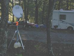
The campground is very family-oriented (lots of RVs-one of which had a satellite dish out front, as the photo below shows! Not exactly "roughing it" when watching Geraldo...), but the camping is comfortable and features easy access to the gorge trails. Another factor to contend with at the park: Highway 441 runs a bridge over the Tallulah Falls dam, and the sound of lots of 70 mph cars and semi-trucks on that bridge is nearly deafening—a roar that can be heard more than a mile from trail heads. But after a long day of hiking, sleep comes easily.
There are two trails (North Rim Trail and South Rim Trail) that skirt along the north and south side of the gorge. Each is less than a mile long, and feature 5-6 overlooks each, have wide, smooth, fairly level, sometimes paved or concrete trail surfaces. Views from the overlooks are stunning. Two of the more noteworthy aspects of these trails are the fact that tightrope walker Karl Wallenda once walked from a North Rim overlook to a tower on the south rim in 1970. In addition, the movie "Deliverance" filmed some of its mountain-side scenes on the north rim. An incredible sight on the North Rim is Tempesta Falls.
The South Rim Trail is over 100 years old, and was destroyed by a tornado in 1994, and rebuilt in 1998.
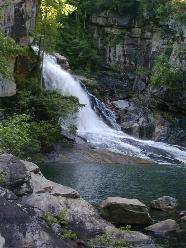
Walking down to the bottom of the gorge requires a permit. After obtaining one from the Interpretive Center, we hike down to Hurricane Falls (photo below left). These falls are very impressive and worth the long walk down the iron grate stairs. (A HUGE number of stairs that requires about 20 minutes to ascend on the way back up.) At the base of the stairs at the falls, there are large boulders in the river that can be walked on. Maureen and I decide to briefly swim in the surprisingly icy cold water, and were almost swept away by the strong current.
On our first morning, we hike the Stoneplace Trail (the area was apparently used as a rock quarry in the past). The trail is about 10 miles roundtrip. It is a shaded, wooded walk, and after a mile or so, allows one to escape the loud howl of highway noise. While the trail lacks scenic vista views, it terminates at the very pretty Lake Tugaloo. Again, we see almost no one on the trail. It feels like we have it all to ourselves.
Overall, there are over 20 miles of trails inside the state park.
Later that day, I kayak Tallulah Falls Lake, which is the lake formed just above the dam (which was built in 1913). The lake is glassy calm, is ringed by pine forest, and contains some historic structures such as old piers from an old bridge, and a historic, brick hydroelectric power plant. The building is just downstream from a small stretch of whitewater that I do not have time to sample on my kayak. The building is an example of how our culture, in the past, honored the "public realm" more so than we do in contemporary times, as the windows to this very industrial building are tall, vertical, arched windows that adds character not seen in more recent buildings.
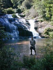
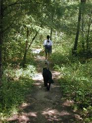
On our last day, we hike the Panther Creek Trail in the Chattahoochee National Forest. This trail is about eight miles long, round-trip. It follows the Panther Creek for its entire length. We find the trail to be extremely attractive and quiet, with a narrow, soft, unpaved trail surface that often passes through vegetation arching over the trail to form a tunnel effect. Again, we see only a tiny trickle of hikers on the trail. Upon reaching Panther Creek Falls at the terminus (photo at right), we again enjoy some brief wading into the cold water. We notice some nice, primitive camp sites along the trail next to the creek, and decide we need to hike the trail again to camp at one of these sites.
A frightful experience occurred on the trail about 1/3 of the way back on the return leg of the hike. Shadow—Maureen's dog—suddenly slows down and begins to emit loud, high-pitched yelps for the next few hours (photo below left shows Maureen with Shadow just before the sting). Her snout swells up, and she begins to grimace each time she shrieks in pain. We are terrified that she perhaps was bitten by a snake. She picks up her pace on the trail—apparently realizing she needs medical help soon (or needs to leave this Trail of Pain). We get back to the trail head, and are confronted with a panicky dilemma: We are out "in the sticks" on a Sunday afternoon. None of the few stores are open when we seek out help, and we finally ask a guy tending a small produce stand. Fortunately, he is a dog owner, and knows of a good vet in a nearby town. He gives directions and we race to the town, only to find the place is closed. Maureen runs off to find a phone to call the emergency 24-hour number, and is greatly relieved to get a call back soon after she leaves a message on the answering machine. Relief also comes when the vet assures her that Shadow was not bitten by a snake, since she would be dead by now if she had. On the orders of the vet, we give Shadow some Bendril, and Shadow slowly stops yelping. A stressful crisis averted.
Overall, we are treated to cooler, mosquito-free air than we are used to in Florida. A pleasant feature found on the trails at this time of year is the blossoming of pink and white azaleas.
We drove up on a Friday. Passing through the Atlanta area, we are greeted by a dramatic indictment of the ruinous idea that a community can build its way out of traffic congestion. Six-, eight- and ten-lane superhighways ring the city. What has the billions of public dollars to build such a gargantuan road system bought the Atlanta area? It has bought nearly continuous, 24-hour-a-day, seven-days-a-week congestion, and costly, seemingly endless urban sprawl. (Even early on Sunday afternoon, we face crushing congestion in the Atlanta area.)
Back to Dom's Voyages and Adventures page.