Hiking
Spring Mill State Park, Indiana (2009)
![]()
A “Volkswalk” is a noncompetitive 10-kilometer walk.
Recently, the American Volksport Association, has ranked the trails at
Fortunately, a friend of mine who is hosting me here in
A new friend in town agrees to join me. We couldn’t have picked a better day – weatherwise – to hike. The weatherman assures us we will have a spectacular November Sunday. Sparklingly bright, sunny, crisp fall day. Temperatures reaching 75 degrees.
I purchase a cranberry turkey sandwich and a chicken wrap at the Bloomington Scholars Inn Bakehouse for the hike nourishment. And on a Sunday following a Indiana University home football game, that means I wait in a very long, crowded, boisterous line for almost 30 minutes to order.
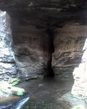
The first cave we come upon is
A long wood stairway leads hikers down to a small, rocky
stream flowing through the forest. We hike upstream and come upon the huge,
imposing
Quickly, I scramble up a small rock wall to gain entrance. Inside, I quickly find I’m blind (like the fish) without a flashlight. But I eventually come to a bend in the relatively large, damp tunnel. Looking down around the bend, there is a long, illuminated corridor in front of me. “Wow. This is amazing,” I mutter under my breath. The corridor and room are surprisingly large.
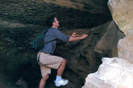
As we leave, I lift myself up a rock face just outside the main entrance, where I am able to crawl back inside the cave and peek at this corridor from a small portal.
Further along on “Trail #3”, we arrive at
In November, the forest is nakedly without leaves, which provides us with a relatively stark (instead of lush) ambience. The trails are thick with fallen leaves at this time of year, and undulate up and down in the depressions and hills of the Karst terrain.
One unfortunate aspect of the park trails is that their names are numbers. Rather than something more romantic such as “Donaldson Cave Trail,” we are on “Trail #3.”
Trails in the park are mostly poorly marked. After one passes the ranger station at the south entrance, the visitor sees no signs pointing out the location of or direction to trails until reaching the northern extreme near Spring Mill Inn. This despite the fact that the park entrance road crosses a number of trail crossings as it you drive north.
 In
addition, when trails cross parking areas, there are often no signs directing
hikers to where the trail starts up again. Similarly, when there is a trail
intersection or fork, there are often no signs informing the hiker which trail
is which. We also had some difficulty with the lack of trail blazes –
particularly with a trail that, at this time of year, is hidden under a thick
layer of leaves.
In
addition, when trails cross parking areas, there are often no signs directing
hikers to where the trail starts up again. Similarly, when there is a trail
intersection or fork, there are often no signs informing the hiker which trail
is which. We also had some difficulty with the lack of trail blazes –
particularly with a trail that, at this time of year, is hidden under a thick
layer of leaves.
The lack of signage was not a significant problem, however, as it simply means that the hiker needs to rely more on the trail map brochure provided at the park.
While the trails at the park are generally pleasant, we never experience a sense of “remoteness” on them. A large percentage of trail distance, for example, is closely parallels park roads. “Civilization” always seems nearby. This “urban park” ambience is probably due, in part, to the relatively small size of the park (the park is 1,319 acres in size).
Curiously, even with perfect Sunday weather on a very pleasant trail system, we find almost no other hikers on the trail.
Overall,
Back to Dom's Voyages and Adventures page.