King Lake Trail, Indian
Peaks Wilderness CO (2011)
![]()
The reviews were compelling for the King Lake Trail in the Indian Peaks
Wilderness: “Spectacular!” “This is a favorite hike in the Indian Peaks.” “It
has it all - alpine lakes, cascading mountain 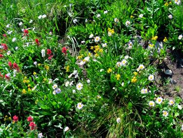 streams,
lush meadows of wildflowers, and spectacular views.”
streams,
lush meadows of wildflowers, and spectacular views.”
As a result, the trail has long been near the top of my list of trails I needed to hike.
I was not disappointed.
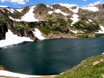
King Lake trail starts at the Hessie trailhead and follows the Boulder Creek through forest, brushy riparian woodland and wet meadows. King Lake lies in a cirque above the treeline, at 11, 431 feet in elevation, just below the continental divide. The trail has a 2400-foot elevation gain. From the trailhead, there is a long, steady incline, but there is no serious steepness until one nears King Lake.
From the trailhead, it takes us 3.5 hours to reach King Lake. Hiking back, which is almost entirely downhill (and much less frequent stops for photos we have already shot on the way up), it takes us 2.5 hours to return to the trailhead. The roundtrip distance is approximately 12 miles.
Our weather is warm and crystal clear for most all of the day, although near the Continental Divide, we find the winds to be rather strong. We scramble behind some large boulders for a wind break.
The trail provides stunning views of dazzling wildflower meadows (so impressive that in my rush to get a good photo of one vibrant cluster, I slipped on a boulder and lacerated the back of my right hand in a number of places). Lakes and creeks are also quite impressive, as are the snow-speckled mountains at this time of year. You will find – as we did – that this hike will compel you to take quite a few photos along the way, as wonderful views are in great abundance.
 At
the end of the day, I designate it one of my best-ever hikes.
At
the end of the day, I designate it one of my best-ever hikes.
Just beyond our King Lake lunch stop, I made the short hike up to the ridgeline above the lake, where I found myself at the Continental Divide, and trail junctions for High Lonesome and Devil’s Thumb. King Lake is part of what is known as the “Southern Loop,” a trail said to be one of the very best in all of Colorado. It includes Devil’s Thumb, Corona, King Lake, the South Fork of Boulder Creek, and Middle Boulder Creek. This 15-mile overnight backpack loop remains on my list of hikes I am eager to try someday soon.
This YouTube link shows a photo movie of this hike: http://www.youtube.com/watch?v=ygX023Gf8qU
Back to Dom's Voyages and Adventures page.