Hiking Cow Creek Trail to
Bridal Falls CO (2011)
![]()
Hiking season for 2011 is
off to a good – but a bit slow – start. Slow because unseasonably cold, snowy
weather extended into the late spring here in the Colorado Rockies. Ann and I
therefore 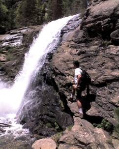 keep our hiking at relatively low elevations as we
give the crystal clear Rocky Mountain sun a chance to melt off the snow and
bring on the wildflowers.
keep our hiking at relatively low elevations as we
give the crystal clear Rocky Mountain sun a chance to melt off the snow and
bring on the wildflowers.
Our hike today takes us
first to a repeat performance venue: Lumpy Ridge Trail in Estes Park. We notice
on the map, however, that we have not hiked to Gem Lake or Bridal Veil Falls in
the Lumpy Ridge system at the northern portion of Rocky Mountain National Park.
A hiker gives us directions
to the Cow Creek trailhead, which will take us to the Falls.
The Cow Creek trailhead is
remembered by Ann and I, but not quite fondly. It is the location we hiked to
last year on the Lumpy Ridge Trail -- a
location that left us several miles (and with very little food or water) from
where we left our car. We asked for directions, and were told that it is about
a mile to walk the dirt road out to the paved roadway where we could probably
find a ride. The dirt road turned out to be over two miles.
This time, we’d leave our
car at Cow Creek…
Cow Creek Trail is quite
scenic. Meadows, pine forests, and a creek flanking the trail most of the way.
The wildflowers were just starting to emerge on this mid-June morning.
Mountains and steep cliffs loom in all directions. Elevation gain for the trail
is quite moderate, making this a relatively easy hike. Hikers are also treated
to a number of smaller waterfalls along the way while approaching Bridal Veil.
After lunch and a few
miles, we arrive at the falls. With the spring run-off, it is roaring
powerfully – kicking up a rooster tail of water as it crashes down from above.
I decide that the cliff walls 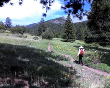 next to us appear to be potentially climbable, so I
search for what appears to be the easiest way up. My plan is to make my way to
a point where I would have a birds eye view of the falls.
next to us appear to be potentially climbable, so I
search for what appears to be the easiest way up. My plan is to make my way to
a point where I would have a birds eye view of the falls.
The rock climbing turns out
to be a bit more than I bargain for, but as a novice rock climber, I go very
slowly and very carefully. Soon I reach an elevation on the wall a LOT higher
than I had planned to go. I inch toward the falls but come upon a section where
the cliff is so vertical that it appears reckless for me to try to navigate it.
Instead, I rest against the rock – hundreds of feet above Cow Creek – and wait
for my body to calm and rest a bit before the descent back to a waiting (and
unseen, from my vantage point) Ann.
I realize two slightly
disconcerting things: First, that it will be more difficult to descend than
ascend (which is not intuitive). And second, that it may not be easy for me to
find the path to descend over (most all of the cliff wall is too steep to
negotiate).
But I manage to safely get
back down. Ann and I hike back to the trailhead – stopping to wade/sit in the
numbingly frigid creek water on the way to refresh ourselves.
The elevation gain from the
trail head to Bridal Veil Falls is 920 feet. Roundtrip distance is 6.1 miles.
This link shows a photo movie of our hike: http://www.youtube.com/watch?v=CXk2a3rEiaQ
Back to Dom's Voyages and Adventures page.