Hiking, biking, rafting
Buena Vista and Salida CO (2011)
![]()
Ann
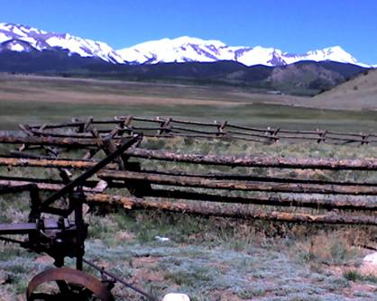
and I have just returned from a 3-day trip to central Colorado. Our departure
is mid-morning on a Tuesday, and Ann wisely has us drive the highly scenic
Route 285 from Denver. We enter a broad, expansive valley of ranches. To our
west/northwest loom the stunning, enormous, snow-capped peaks of the
“Collegiate Mountain Range” in the Rocky Mountains. It is the stereotypical
image of Colorado. Exactly what one pictures when thinking of Colorado and the
Rockies: Ranches bordered by rustic wood fences, and a flat valley floor that
so abruptly juts to the sky from a flat plain with huge, snowy mountains—snow
that seems to glow iridescently in the bright western sun--that it does not
seem real. I have Ann pull over so I can snap a few photos of the incredible
scene before us.
The
mountain range is called “collegiate” as many of these 14,000-plus mountains in
front of us have names such as “Mt Yale” and “Mt Princeton” and “Mt Harvard.”
To our northwest rises Mt Elbert, which, at 14,443 feet,
stands as the highest point in Colorado.
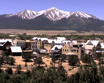
We
arrive in the quite charming town of Buena Vista (pronounced “Boona,” oddly, by the natives). To get settled, we check in
at the “Liars Lodge B&B,” named because the B&B has a fisherman theme,
and fishermen love to tell tall tales about their alleged fishing exploits. The
lodge is spectacular. Vaulted wood ceilings, great deck and room views of the
river and mountains, cookies and wine provided to guests throughout the day,
and a hearty breakfast of omelets, juice, tea, and French Toast
in the morning.
We
park at the town’s River Park adjacent to the mighty Arkansas River, a river
that makes Buena Vista (and Salida, a short distance
to the south) ground zero for some of the best whitewater rafting and kayaking
in the Western Hemisphere.
Here,
we are in awe watching several “playboat” kayakers
playing in the powerful “play holes” of foaming, boiling, hydraulic, stationary
waves rolling back against the water flow, where the kayakers eddy back and
forth and sometimes do back flips with their kayaks. As a lifelong – and flatwater
-- kayaker, I am astonished by the skill we see. It looks impossibly acrobatic
and sometimes suicidal. At 3,500 cubic feet per second (due to an ENORMOUS
runoff of a HUGE snowpack in the Rockies this season, the Arkansas is a
dangerous beast. Indeed, the run I am hoping to raft – The Numbers – is closed
to commercial rafts because it is so over its banks, so powerful and so
rampaging with a long, continuous wave train of rapids.
After
observing the paddlers, we hop on our mountain bikes, cross a river bridge, and
are immediately having a ball riding on the single-track Barbara Whipple
mountain bike trails just across the river from Buena Vista. Fun and rather
technical riding is found on the many loop trails here. Some relatively steep uphills that leave me GASPING for air. I’m in relatively
good shape after just having trained for and run the Bolder Boulder 10K, but
here in the Buena Vista valley, we are at 7,965 feet of elevation, where very
little oxygen is found – even less than the relatively low-elevation of Boulder
at 5,430 feet.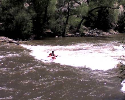
After
the mountain biking, where we are treated to spectacular views of the Buena
Vista valley and the “Collegiates” looming to the
west, we ride a short distance along the river and are stunned to see the power
of the rapids along the river – just a downslope
(granite) stone’s throw from South Main Street in Buena Vista.
We
peddle up to Main Street and immediately come upon our pre-trip Buena Vista
target: Eddyline Brewpub. We sit at the outdoor café
where I enjoy a fabulously tasty, full-bodied Pine Creek Porter brewed by Eddyline, as well as a delicious, chewy calzone. So
enjoyable is the ambience that Ann strolls across the street to check the
prices of some newly-built homes.
We
could live here…
Later,
we dine at The Asian Palate, a nice, flavorful Thai restaurant on Main Street.
After
a peaceful night of sleep at our B&B, we arise Wednesday morning and drive
up a dirt road to catch a glimpse of The Numbers section of the Arkansas. It is
clear to us, when we get out to have a look at the
roaring fury, why this section has been closed. Fast, strong water that would
lead to major, life-threatening worries for any rafter unfortunate enough to be
dumped out of the raft and then in need of having to save his or her life by
desperately (and probably hopelessly) swimming to back to the boat or shore.
We
eat lunch on the river bank and drive to the American Adventure Expeditions
rafting company location, where we had earlier made a reservation. Two paddlers
that were supposed to be on our boat have left to find an ATM due to a faulty
credit card. They don’t return in time and are replaced by three “rookie” raft
guides. Because Ann and I have both rafted fearsome rapids in the past
(Colorado River in the Grand Canyon for Ann, and the dreaded Gauley River in
West Virginia for me), our raft is filled with highly skilled rafters who have
previously experienced extreme conditions. As it turns out, our guide (Henry)
is an excellent raftsman, and he guides us through
the now harrowing “Canyon Doors” rapid, “Pinball” rapid, “Zoom Flume” rapid,
“Graveyard” rapid (one assumes this to be an aptly named stretch), and “Widowmaker” rapid through Brown’s Canyon of the Arkansas
River. With over 100 miles of rapids and 200,000 rafters per year, the Arkansas
is the most popular whitewater river in the world.
Unfortunately
for adrenaline junkie Dom, because our raft contains so much navigational
skill, our raft remains upright for our entire journey, which disappoints me,
as I’ve learned that the most fun one can have in whitewater rafting is to have
the raft dump all of its occupants into the fierce, unforgiving waters.
Nevertheless, I enjoy the wild-eyed experience of paddling in the front part of
the raft (where my paddle speed must be matched by the other paddlers in our
synchronized paddling). Up front, I take the brunt of the walls of whitewater
that frequently come crashing down on us as we charge into the oblivion of huge
waves of rapids. My left hand ends up being shredded into several open blisters
by the strong paddling I do (one needs to paddle as if your life depends on it
– which it does…).
We
end up at Amica’s, another brewpub with excellent
calzones, later in the day in Salida (a delightful
historic town 24 miles south of Buena Vista).
 On Thursday, we set out for
a hike just east of the continental divide near Cottonwood Pass (12,126 feet in
elevation). Our first option is the Ptarmigan Lake Trail, which we are told is
gorgeous. Unfortunately, this north-facing trail is still under several feet of
snow despite our being here on a sunny, warm day on June 9th (only
12 days from the official start of summer). The second recommended trail we opt
for is the Hartenstein Lake Trail nearby. But again we are thwarted, as a
raging creek is too wide and treacherous for us to be willing to cross to
continue on the trail.
On Thursday, we set out for
a hike just east of the continental divide near Cottonwood Pass (12,126 feet in
elevation). Our first option is the Ptarmigan Lake Trail, which we are told is
gorgeous. Unfortunately, this north-facing trail is still under several feet of
snow despite our being here on a sunny, warm day on June 9th (only
12 days from the official start of summer). The second recommended trail we opt
for is the Hartenstein Lake Trail nearby. But again we are thwarted, as a
raging creek is too wide and treacherous for us to be willing to cross to
continue on the trail.
Instead,
we head back to Buena Vista for another Eddyline
beer. Ann perches herself on a large boulder on the river to read a book, and I
return to the mountain bike trail for another hair-raising, technical ride down
trails I have no business riding on so recklessly.
Next
time I return to this area, I intend to hike the two trails we were turned back
from (later in the year, such as July or August), and also to sample the
Monarch Crest Mountain Bike Trail west of Salida,
which we were told is ranked 10th in the world for scenic mountain
bike rides (fabulous views of the Rockies, valleys and lakes).
This link shows a photo movie of our trip: http://www.youtube.com/watch?v=rasbmWaNKg0
Back to Dom's Voyages and Adventures page.