Hiking Mitchell Lake & Blue Lake, Indian Peaks
Wilderness CO (2010)
![]()
My new Boulder friend and I are
still in our “test each other out to find out if we are compatible adventurers
yet” mode.
Our next “test”: Hiking Indian
Peaks Wilderness (and finding out if we can agree on which trail to hike…).
 We opt for the Mitchell Creek trailhead,
which provides access to a number of fabulous trails, including Lake Isabelle.
Because I have recently hiked to Lake Isabelle, we agree on Mitchell Lake and
Blue Lake, which take us on the northern side of Pawnee Peak. It is an easy day
hike of under five miles, round-trip.
We opt for the Mitchell Creek trailhead,
which provides access to a number of fabulous trails, including Lake Isabelle.
Because I have recently hiked to Lake Isabelle, we agree on Mitchell Lake and
Blue Lake, which take us on the northern side of Pawnee Peak. It is an easy day
hike of under five miles, round-trip.
The weather is perfect for hiking
on this bright, sunny Thursday morning on July 1st. Slightly cool compared to Boulder today, as we are over
10,000 feet in elevation.
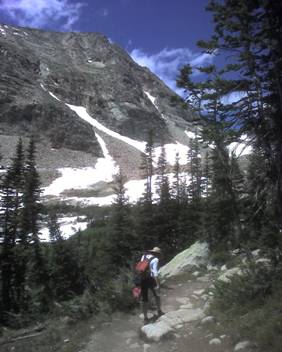
Like many trails in Indian Peaks,
this one has you first pass through a pleasant pine forest. Flanking us a
number of times on both sides are picturesque lakes, early wildflowers (peak
season will not be for another few weeks), and streams.
Summer is still so new in the
Peaks that remnants of snow drifts from the previous winter season still
persist. The trail on this day is rather muddy and often little more than a
rocky creek as summer snowmelt creates a number of streams. Often, we find
ourselves crossing snowfields – particularly when we go off-trail to get a
closer look at lakes and streams near us.
The scenery is stunning and
literally breathtaking. An excellent barometer of the quality of scenery is
that I am unable to stop snapping photos with my Verizon Treo SmartPhone (a phone that I was nearly bullet-proof in the
700 series I have).
Gorgeous,
crystal clear lakes.
Enormous mountain slopes streaked with fingers of snow from the previous snow
season. Grand, seemingly endless vistas.
In addition to being relatively
short, this trail is relatively level, which makes for an ideal choice for
those who are not Olympic in athletic skill. Indeed, 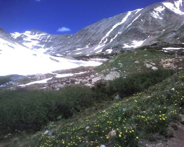 for a short while we hike with an 84-year
old woman who is spry enough, with her hiking poles, to be enjoying the majesty
of the Wilderness.
for a short while we hike with an 84-year
old woman who is spry enough, with her hiking poles, to be enjoying the majesty
of the Wilderness.
To our right looms Mt Audubon
(13,223 feet at the summit), an excellent hike I have previously experienced.
To our left, Pawnee Peak is a few feet shy of 13,000 at its summit.
We reach the Blue Lake terminus
of the hike. In front of us, Blue Lake is still mostly frozen over. A number of
dramatic waterfalls feed the lake from multiple directions. At the edges, the
lake has melted and we can see what appear to be tiny iceberg fingers that form
curving patterns under the strikingly clear ice water. Forming the western
amphitheater of Blue Lake are Mt Toll and Paiute Peak. Paiute stands at over
13,000 feet. Toll reaches just under 13,000 feet in
elevation.
A number of times, we see cute
little marmots scurrying around us playing hide-and-seek.
The Indian Peaks Wilderness is a wilderness area in north central Colorado
managed jointly by the United States Forest Service and the National Park Service within the Arapaho and Roosevelt National Forests and small parts
of the southern section of Rocky Mountain National Park. It borders
the James Peak Wilderness to the south, and
straddles the Continental Divide. The area
encompasses a stretch of the Front Range. It includes
seven peaks over 13,000 feet in elevation. The highest point is North Arapaho
Peak at 13,502 feet. The peaks are all within 100 feet of elevation of each
other. A portion of the area, encompassing the headwaters of North Boulder
Creek, is closed to the public as it is the City of Boulder watershed. Many of the peaks
inside the wilderness area are named after western Native American tribes. Indian Peaks received protected status
in 1978 when Congress designated the Indian Peaks Wilderness Area.
This link shows a photo movie of our hike: http://www.youtube.com/watch?v=g3_IeFEh_GI
By the way, the results of our
“compatibility” test? We are a good match. No whining, complaining, arguing (at
least about the hike, that is), or pouting…
Back to Dom's Voyages and Adventures page.