


Auto Touring in the Smokies
There are over 270 miles of road to choose from in the Smokies. Most are paved, even the gravel roads are maintained in suitable condition for standard passenger cars. The main road running through the park is Newfound Gap Road (US 441). Starting from Cherokee, N.C. or Gatlinburg, TN.
Don't Trust Your Vehicle Navigation System/GPS - This is a suggestion from the NPS website.
"Vehicle Navigation Systems and GPS units may provide inaccurate
information in the mountains—sending drivers the wrong way on one-way
roads or leading them to dead ends in remote areas. Free park road maps
are available in park visitor centers (www.nps.gov/grsm/planyourvisit/directions.htm) ".
Newfound Gap Road The 33-mile drive from Gatlinburg to Cherokee North Carolina along Newfound Gap Road (US 441) is the only route that completely traverses the Great Smoky Mountains National Park. A trip over the Newfound Gap Road has often been compared to a drive from Georgia to Maine in terms of the variety of forest ecosystems one experiences. Starting from either Cherokee, North Carolina or Gatlinburg, Tennessee. You will climb approximately 3,000 feet ascending through cove hardwood, pine-oak, and northern hardwood forest to attain the evergreen spruce-fir forest at Newfound Gap (5,046'). At Newfound Gap is the Rockefeller Memorial; A two-tiered stone structure, this monument is a thank you to the Rockefeller family's $5 million donation to complete the Park's land acquisition. Just south of Newfound Gap is the seven mile Clingmans Dome Road which will lead you to the highest peak in the Smokies, 6,643 feet, the third highest in the Eastern U.S. On clear, pollution-free days, views expand over 100 miles and into seven states. However, air pollution limits average viewing distances to 22 miles. Other attractions along the route include: the Sugarlands Visitor Center, Oconaluftee Visitor Center, Mountain Farm Museum, Mingus Mill, and Sugarlands Valley Nature Trail. Quiet walkways, unforgettable views of the various peaks in the Smokies, a vast variety of trees, flowers, and wildlife; campgrounds and picnic areas; they all await you.
Another view of the Smokies awaits you along the Little River Road leading from Sugarlands to Cades Cove. The road lies on the old logging railroad bed for a distance along the Little River. Roads lead off to Elkmont and Tremont deeper in the park, and to Townsend and Wear Cove. Little River Road becomes the Laurel Creek Road and takes you into Cades Cove.
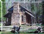
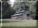
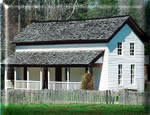
Cades Cove is 2500 acres of open space in the GSMNP. In 1815 Cades Cove was acquired by the state of Tennesse as frontier country. By 1850 the population peaked at 685. Cades Cove road is an 11 mile one-way loop road that circles the cove. As you enter Cades Cove stop and purchase a copy of the auto tour booklet. Cades Cove offers the widest variety of historic buildings in the national park. Along the loop road are 3 churches, a working gristmill, barns, log houses, and many other restored 18th and 19th century structures. Cades Cove also offers some of the best opportunities for wildlife viewing in the park. The best time that I have found for viewing wildlife is early morning before all the traffic builds up. We take a leisurely drive around the loop just looking for animals, we then drive around a second time and stop at the sites along the road. Some of the wildlife seen in the area include; white-tailed deer, black bear (Newfound Gap and Cades Cove are the only places in the park that I have seen bears), coyote, ground hog, wild turkey, raccoon and skunks. Enjoy a picnic at the picnic area by Cades Cove campground.
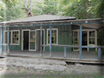
Elkmont, a Ghost Town in the Smokies.
For all the times I have been visiting the Smoky Mountian National
park, up till 2011 I thought Elkmont was just a campground. To my
surprise I found out that Elkmont started out as a logging community
which turn into a resort community. The National Park is in the process
of restoring the old houses and clubhouse. Head to Elkmont campground
and make a left just before you reach the campground. The ranger at the
Welcome Center was very helpful at giving me detail directions. More
information on Elkmont can be found at insidegatlinburg.com.
The Roaring Fork area is a favorite drive of mine. It offers gushing mountain streams, glimpses of old-growth forest, and a number of well-preserved log cabins, gristmills, and other historic buildings. From US 441 in downtown Gatlinburg, turn at stoplight #8 onto Airport Road. As with Cades Cove, stop at the enterence to purchase an auto tour booklet. The Roaring Fork Motor Nature Trail is a one-way narrow, twisting six mile loop, paved road, that runs beside rich forests, waterfalls, and mountain streams (it is not suitable for bicycles, RVs, trailers, or buses and is closed in winter). A portion of the drive travels along an old roadbed constructed in about 1850 by local men who used picks, shovels, and dynamite to clear a level path through the rock. Roaring Fork was then a community of 25 families who all shopped at the same single store and attended the same church and school. Two of their old homesteads, a small tub mill, and a barn are some of the historic buildings preserved along the trail. The Noah "Bud" Ogle self-guiding nature trail provides a walking tour of an authentic mountain farmstead and surrounding hardwood forest. From this trail you can hike to Grotto and Rainbow Falls. Grotto Falls is the only waterfall in the Great Smoky Mountains National Park that you can actually walk behind. Plan your timing right and you can have a picnic lunch next to the stream and refresh your tired feet in the cold water.
Cataloochee: Way off-the-beaten-path is Cataloochee. The End of Cataloochee began in 1928, word was received that the U. S. Government had plans to buy Cataloochee from the residents and establish the Great Smoky Mountain National Park. Cataloochee is more difficult to get to than other areas of the Park. The easiest way to get there is to take Interstate 40 to Exit 20, follow the signs up Route 276 and onto Cove Creek Road. Cataloochee was the biggest settlement in the Smokies; at the turn of the century nearly 200 buildings were scattered around the cove. A variety of historic buildings have been preserved in the valley. You can tour a school, churches, a barn, and several homes in the valley. Five historic buildings are located along the road in the valley. An additional 4 buildings can be reached if you're willing to walk a couple miles down the nearby Little Cataloochee Trail. The Self-guiding Auto Tour booklet provides brief histories of each structure. If you want to get away from all the congestion take a day and visit Cataloochee. It is like Cades Cove without the traffic. This is the only area in the park that you will be able to view the newly released Elk; which I have yet to see. There are 27 sites at the Cataloochee Campground, where you can find respectable trout fishing in Cataloohcee Creek.
"Heintooga-Round Bottom Road is a 15-mile, one-way, gravel road leading from Balsam Mountain Road to Big Cove Road. It takes one hour to drive. The only access to the area is along the Blue Ridge Parkway. Starting from a mile high, this road descends through the Raven Fork drainage basin. A few small vistas open along exposed ledges. The road travels through lush second growth forest and along cascading streams. Heintooga-Round Bottom Road is an opportunity to experience the Great Smokies' solitude and wilderness. Following Raven Fork's playful waters, the road leads into Cherokee, NC along Big Cove Road.
Rich Mountain Road
heads north from Cades Cove over Rich Mountain to Tuckaleechee Cove and
Townsend, TN. The 8-mile road provides beautiful views of Cades Cove.
Many prize-winning photographs come from here. Situated on a dry ridge,
an oak-dominated forest lines the roadside. Once you get outside the
Park, the road becomes steep and winding.
http://www.nps.gov/grsm/planyourvisit/offbeatenpath.htm"